SPOS features improved ice information in 10 ice concentration levels and iceberg information. The information can be used to set restrictions on each level.
Ice concentration
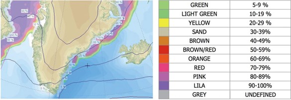
Ice concentration is featured in SPOS in 10 different levels. Each level is displayed in a different color and can be set as Restriction in the Input screen. For the identification of the Ice Concentrations SPOS uses colors. Each color represents the concentration level as shown in the table below:
To visualize ice concentrations, select the checkbox ‘Ice’ in the
‘Elements’ group box in the Weather screen.
Iceberg information
In the North Atlantic the outer iceberg limit is displayed. This limit is indicated by a blue line.
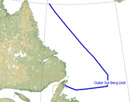
North Atlantic Outer iceberg limit
In the southern hemisphere there is detailed information on the largest icebergs available.
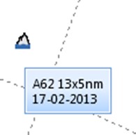
Southern hemisphere iceberg information
Please note that iceberg information is displayed only and will not be used in routing calculations.
Always check other (local) sources of information for the latest warnings!
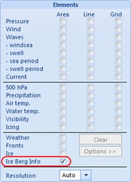
To visualize this information as shown above, select the checkbox
‘Ice Berg info’ in the ‘Elements’ group box in the Weather screen.
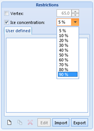
Ice Concentration as restriction
In the Restrictions group box of the Input screen, you may set a maximum level of ice concentration that will be used as restricted area when routing.
The restricted area is thus indicated by a black line around the selected ice concentration level. When activated this line will be visible whether the ice information in the Weather screen is selected or not.
To activate this restriction, you can select the checkbox ‘Ice concentration’ in the ‘Restrictions’ group box in the ‘Input’ screen.