Enhancements:
1. Speed Limits on Areas (Restrictions)
The Restriction function is extended with the possibility to set a speed limit on a restricted area. The routing algorithm will use the restricted speed during the route calculations. For example Right Whale protection zones can be added and SPOS will include this in the voyage plan.
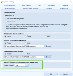
2. International Standard on Route Template Exchange (RTZ1.0 and 1.1)
On the 19th of August 2015, IEC adopted edition 4 of the 61174 standard, where Annex S contains the route exchange format. This route plan exchange format is intended to be used for many purposes. For example, it can be used on board for route plan exchange between main and backup ECDIS, ECDIS and radar, ECDIS and optimization systems, etc. Another example of use is between ship and shore where it can be used to inform the shore about the plan of the vessel; the shore can recommend a route, the shore can optimize a route, etc. This route plan exchange format is based on standardizing a single route plan. The application level of the sender and receiver is assumed to be able to handle multiple route plans for use cases which require availability of multiple routes, for example alternative route plans for the same voyage or route plans for different purposes. A route plan consists of way-points. Each way-point contains information related to the leg from the previous way-point. The route exchange format is a file containing an XML coded version of the route plan. The XML route exchange file uses the extension .rtz.
Currently 2 versions of this .rtz format exist, a 1.0 (official version) and a later, 1.1 version that solves a few minor issues. SPOS supports both formats.
- Functionality implemented:
- Import rtz route template
- Export route template
- Export calculated route as rtz template
- Saving data from imported rtz file that is not used in SPOS and provide it to export file
- Create functionality of revision of route template (merge previous data from rtz file and edited data from SPOS and increment revision field).
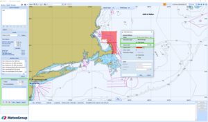
3. Weather Limit Alerts on the Route – Map Display
The parts of a calculated route, where the user’s weather limits (warn levels) are exceeded, are drawn in red. Users can turn this function ON and OFF via the View menu on top of the map.
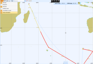
4. Display Course Change Way-Point Numbers on Map
On the map, on calculated routes, the course change points are labelled with their number. Users can turn this ON/OFF via the ‘Show route information’ setting in the View menu above the Map. This setting controls the weather limit on routes, speed labels and route course change point labels.
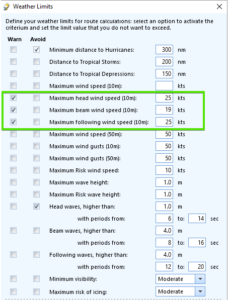
5. Wind Limits for Different Relative Wind Directions
The Weather Limits section in the INPUT tab is extended with the ability to capture wind (10m) limits for different relative directions.
Head, Beam and Following winds (10m) can now be given different weather limits:
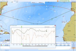
6. Graph-Map Interaction for Routes
When visualizing route info in the graphs section, the position of the mouse in the graph updates the map display synchronously, displaying the ship projected position and the corresponding time step in the weather forecast.
7. New Speed-Fuel Curve Interpolation
The user defined pairs for speed-fuel relation are now used in the route calculations. The method of drawing an average third power line, that did not always go exactly through the user given inputs, is replaced with a new interpolation method. The user is also warned for wrong inputs and has the option to enlarge the graph to visualize the points.

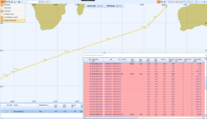
8. Noon Reports Input Checks
The voyage updates and noon reporting function is improved with input checks on fuel consumptions (compared with Remaining on board figures from previous report).
For the Departure and Destination ports, the route template is used to pre-fill the data for the user.
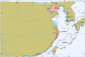
9. China ECA
The China Emission Control Areas are added and can be switched on via the GIS menu above the map.
Fixes:
- Speed percentage for ECA areas was not included in total voyage speed percentage, this has now been added
- Missing parameters Air pressure and temperature and Water temperature added to Route Info table
- Seakeeping: return missing Motion Limit field in route comparison overview
- Copied Profile disappears after closing SPOS without Save
- Trim: returned Drafts in Trim Advice pop-up are now correct
- Route template table and scrolling improved, limit height of table